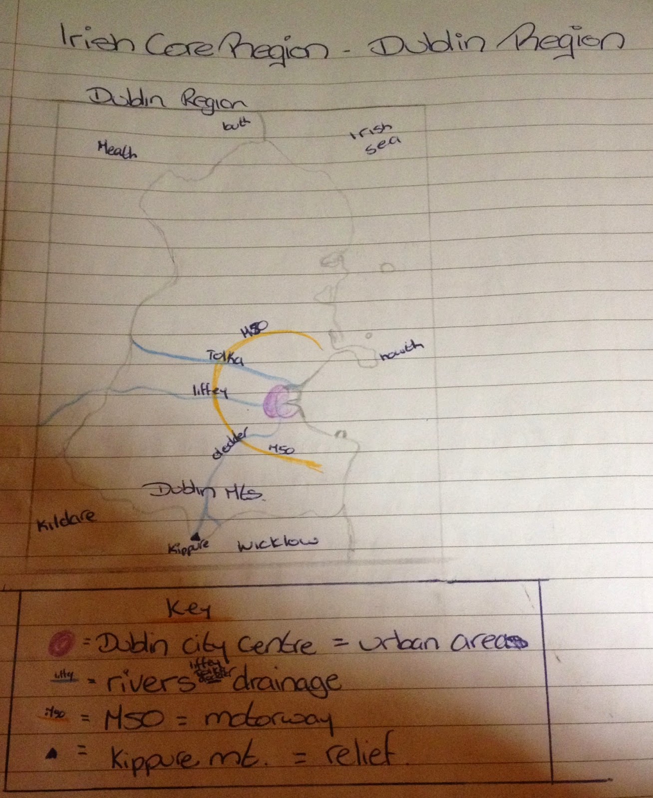
Saturday 27 September 2014

The Dublin Region - Physical Geography & Primary Economic Activities

In this I will write first about physical Geography of the Dublin Region before talking about the primary economic activities as the physical landscape will affect the activities. The primary activities i will talk about are Fishing and Farming. If asked for one primary economic activity i would recommend discussing agriculture and only include the fishing is asked for more than one activity.


Physical Geography

Topography:
  • Mainly flat or undulating 
  • very flat coast line to the north, rises to the south 
  • rises in the south to form the Dublin Mountains
Drainage:
  • region is well drained by the west-to-east flowing Liffey
  • Other rivers include the Tolka and the Dodder
Soil:
  • Brown Earths dominate the region. This fertile soils was laid down over thousands of years due to the decay of deciduous leaves
  • Alluvial soils have been laid down close to the rivers such as the Liffey and Tolka - very fertile
  •  There are poorly formed podzol and peaty soils found to the south of the region where there is higher rainfall and cooler temperatures due to alltitude
Climate:
  • Precipitation: lowlands 800mm pa, uplands 1600mm pa
  • temperature: (mild due to altitude and coastal position) winter - 5-6 degrees, summer - 16 degrees. The winter in the Dublin Mountains would be slightly more severe due to altitude
  • Sunshine: 4 hours per day - higher than most of the country 
  • growth rate - 270 days (temperature above 6 degrees) to the North of the country. 


The combination of the above physical factors leads to the development of specific primary, secondary and tertiary economic activities.


Primary Economic Activities

As the Dublin region is a core region few people are involved in this economic sector. There is little mining and some forestry. The fishing industry is struggling and agriculture is under threat from urban sprawl.


Agriculture

Although few people are employed in agriculture in the Dublin Region, it is still a very important primary economic activity. Two key factors that have affected the development of agriculture are the region's landscape and climate.


The first factor that has affected agriculture in the Dublin region is landscape. The North of the region has a flat or undulating topography. Brown earths dominate the region which are deep and fertile. The good soil and flat land is good for tillage farming. AS a result of this there is a lot of wheat and barley grown. There is also a lot of market gardening, with crops such as potatoes, carrots, onions and cabbages.

The north of the region also has some dairy farming, producing milk as well as cheese, yogurt and other dairy products. The south of the region has the Dublin mountains. As such it is bad for tillage farming. Pasteurial farming of sheep and some dry beef stock is the main agricultural activity in the south of the region.


The second factor that has influenced agriculture in the Dublin region is climate. The Dublin region has an average temperature of 5-6 degrees in winter and 16 degrees in summer. Becasue of its coastal location, it does not get very cold or very hot. This makes it ideal for crop growing as soil needs to be 4 degrees for seeds to grow. AS such there is a lot of tillage farming in the region. The winter temperatures in the Dublin mountains however are slightly more severe than the lowlands. There is approximately 800mm of rain each year in the lowlands of the region. This is perfect for tillage farming. The uplands have about 1600mm each year. This is a bit much for crop growth so the uplands are mainly used for pasteurial farming.


Fishing

The fishing industry in the Dublin region has been in serious decline for the last number of years. Many fish species have been fished to almost exhaustion in the Irish sea. This is being done by both Irish fishermen and foreign boats from country's such as Britain and Spain. Strict quotas have been put in place that limit the amount of fish that can be caught each year in the Irish Sea. Many fishermen have reached these quotas in just 3-4 short months and many are finding that they cannot make a tear-round living from fishing alone. Many fishermen are forced to find part time employment on land or are forced out of the industry altogether.

The two main fishing ports in the region, Howth and Skerries, account for only 3% of Ireland's yearly catch. Fishing in the Dublin region, as an industry, probably has very little future, especially since there is little opportunity for aquaculture. Unlike the West of Ireland, the Dublin region has few suitable locations for fish farms due to busy shipping lanes and a less indented coastline.


If question says ACTIVITY use agriculture, if it says ACTIVITIES shorten agriculture and add in fishing.

Regional Geography: An Irish Core Region - The Dublin Region

For Regional Geography you have to study an Irish Core regional and for this I have done the Dublin Region.


The above map shows the Dublin region on a map of Ireland (ignore the fact that some of it is darker green than the rest)

Here is a map I drew of the Dublin Region, sorry for the bad quality!


Sunday 21 September 2014

Regional Geography - Human Geography of the Western Region

Human Geography of the Western Region 

The Western Region has traditionally been a pole repulsif region. This means that there are more push factors rather than pull factors that drive the population away. Generally, it is younger people who migrate in search of employment opportunities and a better social life. This leaves behind an older, more traditional, workforce who tend to be less innovated. As a result the west of Ireland has a higher dependency ratio than any other part of Ireland. This means that the region has a higher percentage of people who are in the 65+ age bracket.


Aside from being pole repulsif, the region also has a low population density, with only 10% of the country's population, despite having over 20% of the land. The distribution of this population is also unbalanced as it is mainly focused on Galway city. In recent years the regions overall population has increased but rural depopulation has also increased. Almost 400,000 people now live in the Western Region.


Rural depopulation is resulting in the destruction of small rural communities. The cycle of rural depopulation can lead to a reduction in the provision of educational, medical and transport services. The National Development Plan (NDP) set up the LEADER programme. This programme attempts to generate employment in rural areas, to prevent further depopulation. The NDP also set up the Western Development Commission which attempts to promote the region's culture. The most likely way to reduce the problem of out-migration seems to be the development of a strong tourist sector, as tourism is a labour-intensive industry.

Regional Gepgraphy - Tertiary Economic Activities in the Western Region

Tertiary Economic Activities in the Western Region

Western Region 

Tertiary activities - Transport and Tourism 

If the question asks for one tertiary activity, write about tourism. If the question asks for two shorten the below answer on tourism and add in information about transport which can be found in the previous post on secondary economic activities.

Tourism 

The Western region is one of the most attractive tourist regions in Ireland. It has the landscape, activities, food and drink and culture to keep both Irish and international tourists content. 

One of the more interesting aspects on offer is a form of religious tourism. Every year tourists flock to Croagh Patrick for the July Pilgrimage. This involves climbing bare-footed up the scree covered slopes of the Mayo mountain. This unusual event draws tourist to Westport which benefits greatly from the one million tourists who climb the mountain each year. These tourists require food and drink, entertainment and accommodation in local restaurants, bars and hotels. 

Tourists also visit the Marian Shrine in Knock where the Virgin Mary is said to have appeared in the 1800s. Various shops and businesses have grown up in the area to cater fort the passing tourists. Many of the West's 2.5 million tourists each year visit Croagh Patrick and Knock as well as some of the more note worthy religious buildings such as Kylemore Abbey and Galway Cathedral.


A second reason why tourists visit the Western Region is because of the various sporting activities such as hill walking, fishing and adventure racing. Official walking routes have been established such as the Western Way and the Croagh Patrick Heritage Trail, a 60km walking route around Clew Bay. Adventure racing is a hugely popular and growing tourist attraction. Gaelforce West has become an annual event with over 2500 athletes running, cycling, climbing and kayaking from Galway to Mayo. Westport, the base for this race, is entirely booked out on the second last week of every August. 

In Roscommon there are an abundance of fishing locations especially along the River Shannon and in lakes like Lough Allen and Lough Rea. Fishermen can hire boats and fishing equipment and sail north or south alone our longest river. Galway city also has a wealth of tourist attractions. Aside from the Galway Races there is soccer in Terryland Park and Gaelic games in Pierce Stadium.

Saturday 20 September 2014

Regional Geography - Secondary Economic Activities in the Western Region

Secondary Economic Activities in the Western Region

The basis for a strong secondary or manufacturing sector is the strength of the primary sector. It is also based on the location of the region, its landscape and its population.

The manufacturing sector is poorly developed in the western region, in comparison to much of the rest of the country.


One reason for this is the Western regions workforce. The western region has a smaller pool of skilled workers than much of the rest of the country. In part this has to do with the regions smaller population as less than 10% of the country's population live in the west. In addition there are fewer third level centres of education. While somewhere like the Dublin region has UCD, DCU, DIT, Trinity and many others the West has only UCG and GMIT. International organisations such as Intel, Dell and Microsoft have overlooked the region as a result of this factor.

There is also a smaller pool of unskilled workers. There is only one city in the area and very few towns with a population of over 5000 people. As a result the West's industrial sectors is mainly focused around Galway, the place with the largest and most skilled workforce. 60% of Roscommon's industry is based on food processing. Galway is more focused on high tec industries like computers, medical supplies and chemicals. 17% of GAlway's population are employed in the secondary sector.

The second factor that has held back development of secondary economic activities is the regions poor infrastructure. Traditionally the west has lagged behind other regions in this regard. The Western region does have air, rail, road and port access, mainly service in each of these areas when compared to somewhere like the Dublin region. Until recently the West had no strip of motorway. The M6 finally opened in 2010, linking Galway with Dublin. This allows for easier access of people, raw materials and finished products. There are proposals that more motorway will exist in this region. The western region has air access through both Galway and Knock airports. They both offer internal and limited international flights but both operate on a far smaller scale than Dublin airport.

Another proof that the West lags behind in infrastructural development is in relation to its light rail. While Dublin has had the Luas for many years now, Galway's 'Gluas' is still only in the proposal stage. This lack of development of a local transport network makes industrial development less likely. One of the most limiting aspects is the West's weak electrical grid. Even if power-hungry industries were willing to over look the lack of good transport, they would still be unable to set up in the region, due to limited supply of electricity. 


If the question asks for factors that have affected the development of industry, give both workforce and infrastructure but shorten both to suit (does not have to be a 50/50 balance)
Beware that other factors have affected the development of industry:
  • smaller market
  • distance from core regions, industry typically locates in core areas
  • lack of political power - voice
  • one good point is grants are available tax free/low tax incentives

Regional Geography - Primary Economic Activities in the Western Region

 Primary Economic Activities in the Western Region

For this essay farming and fishing are two primary economic activities that can be used if it asked for two ( but it does not have to be 50/50 split between them. If asked for one then write in detail on farming. Physical landscape and climate are two factors which impact on the primary economic activity.
If writing about both economic activities shorten the farming part as it is not all needed.


One peripheral region in Ireland that I have studied is the Western region. In this region primary economic activities such as farming and fishing are of the up-most importance.


In the area of agriculture the physical landscape impacts greatly on the type of farming carried out. Roscommon does have large areas of lowland but much of it is poorly suited to agriculture as it is covered in shallow brown earths, which is not deep enough for good crop growth. Other areas are covered in grey and podzol which are too acidic and prone to water-logging. This means that there is very little tillage farming. Most land is used as pasture land for beef stock. In Mayo and Galway the topography (landscape) is best described as hilly. Galway as mountains such as Sleeve Aughty and the Twelve Pins. Mayo has the Ox and Nephan beg ranges. The soil in these areas is described as peaty. This is very poor land for crop growth as the soil is acid ridge and boggy and the slopes are too steep. The most common type of agriculture practiced is the grazing of sheep. In the east of Galway there is some brown earths but they are over limestone and are very shallow. As such they dry out quickly in summer and farmers are again limited to pastural farming. As a result of the western regions landscape and soil, less than 2 percent of the land is used for tillage crops.


Ireland's climate is described as cool temperate oceanic. However it is slightly more harsh in the Western Region, the main difference is in terms of temperature as Dublin's average summer temperate is 2 degrees hotter than the western region (16 degrees Vs 14 degrees). This affects agriculture as there is a shorter growing season as soil temperature needs to be 4 degrees before growth will take place. This temperature is more often reached in the east rather than the west. Precipitation is also higher in the west than the east. The West receives 2000mm of rain per year, compared to 1000mm on the Dublin Region. These levels are too high for successful crop growth. This leads to boggy, water-logged soil that is not suited to tillage farming.


Extra agriculture facts
  • Farming is vital to the west but it is generally ineffective - it is labour intensive with a poor return.
  • 30% of farms in the west are under 10 hectares (25 acres)
  • 30% of farmers are over 65 - large percentage not pro-innovation, traditional methods
  • most farms survive on EU subsidies


Fishing

  • Perfect location for fishing as it has a very indented coastline full of sheltered bays and harbours.
  • Plankton-rich waters due to the shallow continental shelf which is less than 200m deep resulting in large fish stocks
  • The Irish box - an area around Ireland where no one else has fishing rights
  • North Atlantic Drift (NAD) bring a mix of waters to the west coast therefore bringing a wide range of fish while also preventing harbours from freezing over in winter.
  • Recent development - aquaculture (fish farming) - growth industry - some fish farms in the west include salmon and shellfish including oysters and muscles - Galway Bay, clew bay, Kilary harbour
  • fish becoming more popular as people are more health conscious
  • despite all obvious benefits this primary activity is struggling (unattractive lifestyle, increasing EU laws, dangerous)

Regional Geography - The Western Region

The Western Region

A Peripheral Irish Region


The Western Region is a peripheral Irish region which is made up of the counties Mayo, Galway and Roscommon.  The map above shows the region on a full map of Ireland. You may be asked to draw that in an exam although it is unlikely. 

It is far more likely to be asked to draw a detailed map of the Western Region which is just of the three counties. I have uploaded a map I have draw of the region which can be seen below. 
In the exam you may be asked to identify various physical features or urban centres so I have marked in the county towns of the three counties as well as rivers, lakes and mountain ranges in the region. 

The region is bordered by Sligo, Leitrim, West Meath, Tipperary and Clare as well as the Atlantic Ocean.


Leaving Cert Regional Geography

The next few posts I put up are going to be sample essays for Leaving Cert Regional Geography.


The regional Geography section is divided up into different types of regional and these are the regions I have studied:

Peripheral Irish Region - Western Region
Urban Irish Region - Dublin Region
Peripheral non-Irish, European Region - Mezzogiorno
Urban non-Irish, European Region - Paris Basin
Continental/Sub-continental Region - India


I will put up a number of essays on each one relating to:
  • The physical Landscape 
  • Primary economic activities
  • secondary economic activities
  • tertiary economic activities
  • culture in the region
  • social problems 
  • growth of a region 
  • and some more

I will not have an essay on each one of these but I will have them on enough to cover you for example culture in a European region can be answered on either Paris or Italy so i might just have put up one. 
There are other regions which will answer these questions but these are the ones I have studied. 

The way geography essay questions are marked is with SRPs. there are 30 marks for an essay question. SRP is specific, relevant, point. This means you get one SRP for each piece of new, relevant information. At higher level each SRP is worth 2 marks so these for you need to write 30 SRPS. At ordinary level each is worth 3 marks so you need to write 10 SRPS. There is no point writing pages of answers that is waffle and repeating information over and over and putting in things that are not relevant because they will not count. When you have written an essay answer read through it marking each sentence which you think is an SRP and count how many you have. 

Friday 5 September 2014

Home Ec - Vitamins and Minerals - Vitamin C,. Folic Acid, Calcium & Iron

Notes on Vitamin C, Folate/Folic Acid, Calcium and Iron
Sorry for the weird layout it wouldn't upload properly for me so i had to do it in sections but hope it is some help! 
If anyone wants the actual document of this or any of the other charts on Vitamins/minerals then message me with your email address and i will send them to you!